|
Update: Tropical Storm Bands Lash Central Florida with Wind and Rain 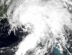 June 6, 2013 | WMFE - As of the 2pm update, Tropical Storm Andrea is centered 35 miles west-southwest of Cedar Key, with tropical storm force winds extending outward up to 140 miles east of the center. [Image: Tropical Storm Andrea Satellite Photo] The storm is moving a bit faster, picking up speed as it heads northeast at about 17 miles per hour. Acceleration is expected to continue. Andrea’s maximum sustained winds of 60 miles per hour remain unchanged. It is expected to make landfall in Florida's Big Bend area in the late afternoon or early evening hours before moving across southeastern Georgia. Tropical storm warnings cover Florida's west coast from Boca Grande to Indian Pass, and on Florida's east coast from Flagler Beach northward to Virginia. Marion and Sumter counties are also under tropical storm warnings. Orange, Seminole, Brevard, Volusia, Lake and Osceola counties are under tornado watches until 10pm. Andrea’s rain bands are expected to continue bringing heavy rain and high winds to Central Florida throughout the day, and possibly into Friday’s early morning hours. Wind gusts of 40 to 50 miles per hour have been reported in various areas across Central Florida. Forecasters are predicting between 2 and 6 inches of rain. Some weakening is forecast tonight and early Friday while the center of Andrea moves into Georgia, the Carolinas and the Chesapeake area in the coming days. Andrea should lose tropical characteristics in about 36 to 48 hours. |
|
|