|
Tropical Storm Arthur Forms Off Florida's East Coast 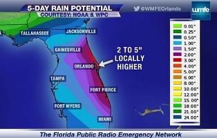 July 1, 2014 | WMFE, Orlando - The first named storm of the Atlantic hurricane season is swirling off Central Florida's coastline, about 70 miles east-southeast of Cape Canaveral. Tropical Storm Arthur is packing 40 mile-per-hour winds and moving slowly northwest. Florida Public Radio Emergency Network meteorologist Jeff Huffman says the system is expected to turn northeast within the next several hours, keeping most of Arthur’s impact offshore. Coastal Brevard and Volusia Counties are under a tropical storm watch. Huffman says over the next 24 hours, our weather pattern will look a typical summer day…with slightly stronger storms. “It’s basically a general trend of more thunderstorms in the afternoon, drying out in the evening hours,” says Huffman. “Now, some of those storms – I think especially tomorrow – could be a lot stronger, and the skies are going to look a lot meaner, but it’s really just heavy rains and gusty winds when these little squalls are moving through and rotating around Tropical Storm Arthur.” Arthur is expected to gain speed and strength as it moves away from Florida late Wednesday into early Thursday, eventually becoming a hurricane off the coast of South Carolina late Thursday. |
|